Uncategorized
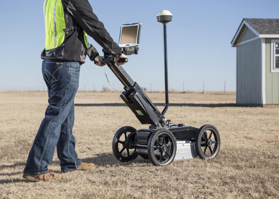
Perry, Okla. – Subsite® Electronics, a Charles Machine Works Company, has introduced the 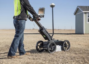 2550GR Ground Penetrating Radar System featuring a new, user-friendly Window’s-based interface that will provide operators with a number of productivity enhancing benefits.
“The 2550GR offers all the same great features as our proven 2450GR,” said Matt Lumbers, product manager, utility locating systems, Subsite Electronics. “It’s ideal for locating any type of utility conduit or piping—metallic or non-metallic, including PVC—beneath soil, rock, pavement, and other surfaces. Plus, we’ve added a number of important software upgrades that will simplify operation and improve performance.”
New software for the 2550GR is designed to make users more efficient. Easy GPS connectivity allows operators to see their path and marks in real-time as they scan. A new wireless connection enables users to easily download web-based maps such as Google Earth.
A new one-touch recalibration button lets operators transition from one scanning surface to another quickly and easily, while the earth-engaged antenna provides better contact on uneven terrain and reduces signal loss.
“We listened to users in the field and have been able to improve the operator experience with significant software upgrades,” Lumbers said.
The 2550GR locates both metallic and non-metallic pipes and cables to allow one-pass locates at depths of up to 19.7 feet (6 m), depending on soil conditions and antenna selection. A 5.6 mph (9 km/h) survey speed and digitally controlled radar allow the 2550GR to provide fast, clear images.
In addition to utility mapping efforts, the 2550GR’s advanced locating capability makes it ideal for a wide range of other applications including void and sinkhole detection, concrete detection, and locating underground storage tanks.
For more information on this product and Subsite® Electronics, visit www.subsite.com or any of our social media channels – Facebook, Flickr, Twitter, Google+, LinkedIn and YouTube. You can contact us at info@subsite.com or 800-846-2713.
About Subsite® Electronics
Subsite® Electronics, a Charles Machine Works Company, is committed to providing underground construction professionals the most comprehensive suite of electronic products in the industry, including utility locators, Horizontal Directional Drilling (HDD) guidance equipment and equipment machine controls. By utilizing innovative technologies, extensive market feedback and outstanding customer support, Subsite Electronics has established itself as the premier source of electronic technology to support the installation or maintenance of underground pipe and cable.
About Charles Machine Works
Established in 1902, Charles Machine Works, an employee-owned company, founded in Perry, Oklahoma, is the only manufacturer and global distributor that solely exists to make underground utility construction profitable. Our family of companies includes Ditch Witch®, Subsite® Electronics, DW/TXS®, HammerHead®, Radius® HDD, American Augers®, Trencor® and MTI® Equipment. For more information, visit charlesmachine.works.
Uncategorized
THOMPSON, CONNECTICUT USA, February 11, 2016– Numa, the leading designer and 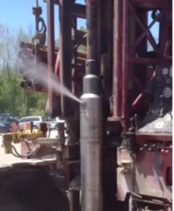 manufacturer of down hole hammers and bits, has released a Vortex Backhead design that improves drilling performance and hammer/bit life. It is available for Numa’s 12” hammer line when drilling conditions require a significant amount of water injection.
Typically when water is injected into the air supply of a conventional backhead, the water will travel through all hammer components and exhaust out the bottom of the bit to improve hole cleaning. Water is not a concern when small volumes are used but a drop-off of drilling performance can occur when significant amounts of water are required. Drawbacks can include slower drilling due to wet bottom conditions and a reduction in hammer/bit life due to cavitation from water.
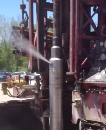
The Numa Vortex Backhead avoids a drop-off of drilling performance by ejecting water out the top of the backhead before it can go through internal hammer components. The design allows for drillers to realize the benefits of water injection without the wear and loss of hammer performance. Numa engineers have accomplished this by creating a spinning process (vortex) in the backhead that leverages the density difference between water and air. Fluids entering the top end of the hammer are spun, pushing heavy material (water) to the outside to be ejected out the top of the backhead. Lighter material (air) stays to the inside and travels down the feed tube to power the hammer and clean the bottom of the hole. The amount of water ejected by the Vortex Backhead can be controlled by the two jets, or chokes, found at the top of the backhead. A standard hammer is supplied with 1/8”, 3/16”, and 1/4” jets that can be changed to control water injection according to drilling preference and conditions.
Benefits of using the Numa Vortex Backhead while injecting significant amount of water include:
· Improved drilling performance through higher impact energy and limited wet bottom conditions.
· Reduced wear from a reduction in non-productive exhaust flow up the outside of hammer/bit.
· Increased hammer/bit life due to the removal of solid particulate from passing through components.
For more information, please email info@numahammers.com, call 860.923.9551, or visit www.numahammers.com.
ABOUT NUMA
Numa is the global leader in the design and manufacturing of down hole hammers and bits for drilling vertical, horizontal, and reverse circulation holes from 3½ to 48 inches (89 – 1,219 mm) in diameter. Numa’s products are used in over 105 countries drilling in a wide range of industries including Construction, Foundation, Micro Piling, Oil & Gas, Quarry, Mining, Utility, Geothermal, Environmental, Horizontal, and Water Well.
Foremost to the success of our customers is Numa’s personal service and technological expertise. Numa is dedicated to supporting customers on the job site and is constantly talking to drillers around the world to get first hand input about the products required for today’s demanding drilling environment. Being so close to drillers’ needs has allowed Numa to develop 13 patents for ground breaking drilling technology and produce over 100 different DTH hammer and bit models in a state-of-the-art manufacturing facility.
Uncategorized
(New York, N.Y.) In an action that will protect people’s health and the environment, and benefit riverfront communities, the U.S. Environmental Protection Agency today finalized a plan to remove 3.5 million cubic yards of toxic sediment from the lower eight miles of the Passaic River in New Jersey, followed by capping that entire stretch of river bottom. The sediment in the Passaic River is severely contaminated with dioxin, PCBs, heavy metals, pesticides and other contaminants from more than a century of industrial activity. The lower eight miles of the Passaic is the most heavily contaminated section of the river. Ninety percent of the volume of contaminated sediments in the river are in the lower eight miles.
Key elements of the EPA cleanup plan:
· 3.5 million cubic yards of contaminated sediment will be removed by dredging the river bottom, bank-to-bank, from Newark Bay to the Belleville/Newark border.
· Over 100 pollutants identified
· Approximately 100 companies are potentially responsible for generating and releasing the pollution
· Sediment will be dewatered and transported likely by train for disposal. Dredged sediment will be sent to licensed, permitted facilities designed to accept the type of contaminants in the sediment.
· After dredging, the entire lower eight miles of the river will be capped bank-to-bank. The cap will isolate the remaining contaminated sediment, effectively eliminating the movement of a major source of contamination to the rest of the river and Newark Bay.
· The cleanup is estimated to cost $1.38 billion
“The Passaic River has been seriously damaged by over a century of pollution. Extraordinarily high concentrations of dioxin, PCBs, heavy metals and pesticides have robbed the people of New Jersey from being able to use this natural resource. The EPA’s cleanup plan will improve water quality, protect public health, revitalize waterfront areas and create hundreds of new jobs. This plan is one of the most comprehensive in the nation and will help restore a badly damaged river,” said Judith A. Enck, EPA Regional Administrator.
“The remediation of the Passaic River has been a priority for the Christie Administration and the Record of Decision for this clean-up plan is the culmination of decades of studies and analyses and efforts, with cooperative efforts from multiple interests mutually working toward the common goal of restoring the river. EPA Region 2 has also been a tremendous partner in this effort,” DEP Commissioner Bob Martin said. “This workable, realistic remedy will reduce the ongoing threat to public health and the environment and, ultimately, will result in our goal of spurring economic growth along the Passaic River and throughout Northern New Jersey.”
A major source of dioxin in the river was pollution from the former Diamond Alkali facility in Newark, where the production of Agent Orange and other pesticides during the 1960s generated dioxin that contaminated the land and the river. Fish and shellfish in the lower Passaic and Newark Bay are highly contaminated with mercury, PCBs and dioxin. Fisheries along the river have long been closed due to the contamination. Catching crabs is prohibited, as is consumption of fish and crab taken from the Lower Passaic River. Local plans for riverfront development have also been hindered because of pollution.
The lower 17 miles of the Passaic River, which stretches from its mouth at Newark Bay to the Dundee Dam, are part of the Diamond Alkali Superfund site. The Diamond Alkali site was added to the federal Superfund List in 1984. From 1983 to 2001 EPA-directed cleanup work was conducted on land at the former Diamond Alkali facility and in the streets and homes near it.
This final plan builds on dredging that has already occurred in two smaller areas with high concentrations of contaminants. In 2012, the EPA oversaw dredging in the Passaic near the former Diamond Alkali facility in Newark. About 40,000 cubic yards of the most highly dioxin contaminated sediment were removed, treated and then transported by rail to licensed disposal facilities out of state. In 2013, the EPA oversaw dredging of approximately 16,000 cubic yards of highly contaminated sediment from a half-mile stretch of the Passaic River that runs by Riverside County Park North in Lyndhurst, New Jersey. This area is located about 11 miles north of the river mouth and outside of the lower eight miles addressed in today’s announcement.
In the lower Passaic River, there is an approximately 10-to-15-foot deep reservoir of contaminated fine-grained sediment in the lower eight miles of the river. Under this plan, about 3.5 million cubic yards of contaminated sediment will be dredged and removed from the Passaic River. Once the top layer of contaminated sediment is removed from the river, a protective cap will be placed over the area that was dredged. The cap will consist of two feet of sand except along the shore where it will be one foot of sand and one foot of materials to support habitat for fish and plants. The cap will be monitored and maintained to ensure that the cleanup remains effective. In the 1.7 miles closest to Newark Bay, deeper dredging will occur to allow current commercial navigation to continue. Based on further assessment of the reasonably anticipated navigational uses, the EPA expects less depth in parts of the navigation channel than was contemplated in the 2014 proposed plan.
Because of the nature and complexity of the Passaic River contamination, the EPA divided the investigation and consideration of cleanup options into two studies – one of the 17-mile stretch of the Lower Passaic from its mouth to the Dundee Dam and the other focused on just the lower eight miles. Information gained from the 17-mile study was integrated into the EPA’s Record of Decision for the cleanup of the lower eight miles. A portion of Newark Bay is also being studied by one of the parties potentially responsible for the contamination, with EPA oversight.
The Superfund program operates on the principle that polluters should pay for the cleanups, not taxpayers. The EPA searches for parties legally responsible for the contamination at sites that are placed on the Superfund list and seeks to hold those parties accountable for the costs of investigations and cleanups. Most of the work to-date to clean up the Passaic has been performed by parties responsible for the contamination. The EPA will pursue agreements to ensure that the cleanup work in the lower eight miles will be carried out and paid for by those responsible for the pollution as required by the Superfund law.
The entire record of decision for the lower eight miles of the Passaic River is available at https://semspub.epa.gov/src/collection/02/AR63167
Follow EPA Region 2 on Twitter at http://www.twitter.com/eparegion2 and visit our Facebook page,http://www.facebook.com/eparegion2
Uncategorized
Recent breakthrough marks triumph over Mixed Ground Conditions
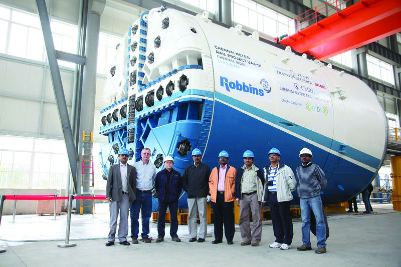
On January 27, 2016, a Robbins mixed ground EPB broke through at Chennai Metro, finishing up a challenging second drive that saw the full gamut of difficult conditions. The 1,027 m long second drive for the machine was part of Lot UAA-01 on Line 1 of the city’s metro, consisting of two parallel 1.0 km (0.6 mi) tunnels running from the Washermanpet area towards Chennai International Airport. Contractor Afcons Infrastructure Ltd. reflected on the breakthrough: “We are really proud of our executing team, who have maintained a high standard of quality. We didn’t record any water leakage or settlement at the surface, and we have demonstrated a high standard of safety in the tunnel during construction,” said Mr. Gopal Dey, Sr. Manager for Afcons.
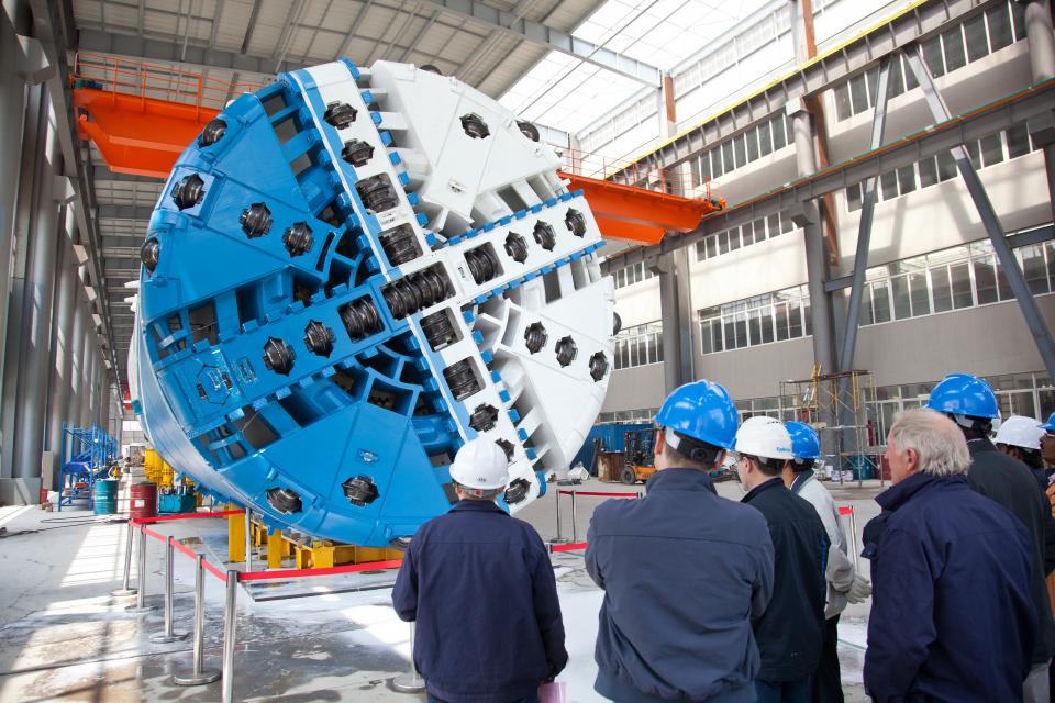
The 6.65 m (21.8 ft) diameter Robbins EPB was designed to excavate granite, sand, silt, and clay with boulders up to 300 mm (12 inches) in diameter. The specialized design utilized a combination of 17-inch diameter disc cutters as well as soft ground tools. Small grippers located around the circumference of the machine’s shield allowed for cutterhead stabilization in harder ground, while additionally reacting the forces needed to pull the cutterhead back from the face in difficult conditions.
The TBM was launched on its initial drive in January 2012 from a 28 m (92 ft) deep starting pit. Challenges began nearly from the outset. The TBM bored into mixed face conditions that contained varying strengths of granite, from weathered to hard granite of 150 MPa (21,700 psi) UCS. The unexpectedly hard rock caused high cutter consumption rates and slowed advance.
A crew of Robbins Field Service personnel and engineers assisted Afcons in remedying the problem. Robbins India provided a geologist who carried out face mapping for the whole of the first drive, in both hyperbaric and open mode conditions on a daily basis. The data not only assisted the crew in operating the TBM, but also provided a comprehensive geological record for the second drive. With the data gleaned from the geological investigation, Robbins was able to advise Afcons on the optimal operating parameters to get through the difficult conditions, including cutterhead RPM, thrust pressure, penetration rate, and cutterhead torque. The parameters also resulted in a reduced cutter consumption rate.
Contractor Afcons was pleased with the help they received: “The Robbins Field Service team extended very good services to us, particularly in the mixed face & full face rock when they deployed their Geologist for face mapping. This helped us to understand the strata ahead of us, and based on this the TBM advance rate and operating parameters were decided,” said Mr. V. Manivannan, Executive Vice Presidentfor Afcons.
The TBM was launched on its second tunnel in February 2015. Conditions were just as difficult as the first drive, but now the team approached it with experience: “We experienced very high water pressure in this alignment, as the water table in Chennai is just 1.5 m (5 ft) underground and the strata above the crown included silty sand, clay and weathered rock. It was very important for us to maintain the earth pressure to reduce the inflow of water, and to avoid any settlement on the surface with proper grouting,” said Dey. Despite the challenges the TBM was able to complete a section below the Koovam River without any water flowing into the tunnel. The machine achieved up to 12.6 m (41 ft) in one day and 62 m (203 ft) in one week.
The TBM broke through into a receiving shaft, utilizing a unique setup for the second time that had the machine emerging under water. “These were the first breakthroughs in India under wet conditions in the retrieval shaft, which is 30 m (98 ft) below the ground level. The retrieval shaft was filled with Bentonite slurry 10 m (33 ft) from the base slab in order to arrest water entry from outside the diaphragm wall,” explained Manivannan.
The completed sections of tunnel will now be commissioned as part of Line 1, a 32.1 km (19.9 mi) long route in total with 14.3 km (8.9 mi) underground and a total of 17 stations. The southeastern Indian city of Chennai is a rapidly growing technological and industrial center with a population of more than 8.2 million people and a high need for alternate means of transportation.
Image 1:The 6.65 m (21.8 ft) diameter Robbins EPB was designed to excavate granite, sand, silt, and clay with boulders up to 300 mm (12 inches) in diameter.
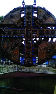
Image 2:The Robbins TBM, for contractor Afcons Infrastructure Ltd., was launched on its initial drive in January 2012.
Image 3: The rugged Robbins EPB bored through unexpectedly hard granite rock in two parallel 1.0 km (0.6 mi) drives.
Uncategorized
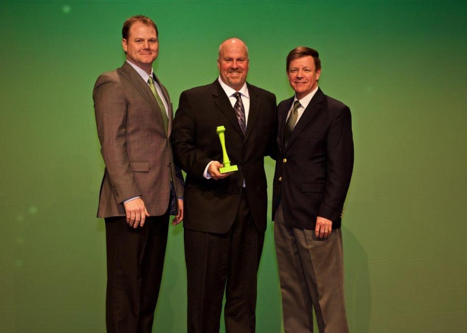
Perry, Okla. –Subsite® Electronics, a Charles Machine Works Company, recognized 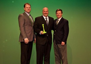 with the Top Volume Electronics Dealer Award and the Top TK Conversion Salesman Award at the 2016 Ditch Witch Dealer Conferences.
“The Top Volume Electronics Dealer Award recognizes a dealership’s exceptional efforts to provide customers with the Subsite products, expertise and service needed to perform their jobs”, said Mark Whiteman, President of Subsite Electronics. “We congratulate Ditch Witch Midwest for its success in utilizing our products to give underground construction customers confidence in their ability to complete jobs safely and productively.” This award is the highest level of recognition for a Ditch Witch dealership’s Subsite product sales performance.
Ditch Witch Midwest salesman Scott Geller was also awarded the Top TK Conversion Salesman Award. This award recognizes the salesman with the most 2015 TK HDD guidance system conversions (trade-ins).
Accepting these awards for Ditch Witch Midwest was Tim Conover, Sales Manager.
Ditch Witch of Midwest carries the industry’s broadest line of underground construction equipment including trenchers, horizontal directional drills, Subsite Electronics, mini excavators, vibratory plows, mini skid steers and trenchless equipment. Since 1970 their pledge has been “Customer First” and they hope this message is clear with honest pricing and reliable service.
With locations in Carol Stream, IL, Brownsburg, IN, Fort Wayne, IN, Kaukauna, WI and Waukesha, WI, Ditch Witch Midwest has been helping underground construction customer be more productive for more than 46 years. For more information on Ditch Witch Midwest, please visit www.ditchwitchmidwest.com.
Photo: Top Volume Electronics Dealer Award & Top TK Conversion Salesman Award
{left to right: John Lamerton, Subsite Electronics Global Sales Manager; Tim Conover, Ditch Witch Midwest; and Mark Whiteman, Subsite Electronics President}
 2550GR Ground Penetrating Radar System featuring a new, user-friendly Window’s-based interface that will provide operators with a number of productivity enhancing benefits.